
In some towns of Calabria you can breathe the smell of ancient things, of respect, of welcome, of discovery, of wonder. During this journey from the Tyrrhenian to the Ionian, that child woke up who marvels at simple things, colors, smells and flavors.
Pass from the modernity and worldliness of Soverato and then find yourself immersed in the ancient villages that come back to life of Petrizzi, San Vito sul Ionio and Monterosso Calabro, ending on the shining Pizzo. The beech trees and the lakes of Angitola and Acero have restored serenity to my spirit.
Combining history, nature and friends is the right shaker for an explosive drink that gives you energy and energy to explore the world. And like every journey, step by step, you strip away all that is superfluous, the essential remains in you and return to a different everyday life. What I carry inside is a message of recovery, of wanting to resume living and changing, this is what this land with its places and its inhabitants whispered to me.
Luca Casaburi
If you are a trekking enthusiast or if you like to explore a territory in search of its natural beauties, you must not miss the opportunity to do the Kalabria Coast to Coast .
The path will take you from the Ionian beaches of the Costa degli Aranci through a path that unravels in the mountainous territory of the Preserre Calabre until you reach the Costa degli Dei washed by the Tyrrhenian Sea . You will then be able to pass from the white sands of Soverato from where you start, up to the golden ones of Pizzo .
Divided into three stages for a total of 55 kilometers , the Kalabria Coast to Coast Walk will allow you to discover landscapes where nature is respected, whether these fields cultivated with corn and prickly pears or virgin chestnut and beech woods. You will enter a still wild territory that has managed to keep intact the flavors of the past jealously guarded from generation to generation.
The walk is well organized and proposed by Kalabria Trekking and all the information is available on the official website www.kalabriatrekking.it
We walked the Kalabria Coast to Coast path with the ASD Trekking Cava Association and videos, photos and tracks were shared below thanks to their support.
The traveler’s passport
Like any self-respecting journey, the traveler’s passport is present . It is the document that identifies the walker on the route of the KCTC Way.
The traveler must have it with him to be identified as such and have access to the agreements on all the accommodation facilities located along the Way. In each country or structure where you will be hosted you will receive a stamp, until the completion of the course.
The passport is free, but you can contribute with a small voluntary donation to support the Way in maintenance costs, as it is a self-financed Way and the trails also need to be maintained.
This is issued when you check-in in Soverato or Pizzo and is used to obtain the testimonium , the document that certifies the completion of the Kalabria Coast to Coast Walk.
The stages
As suggested by the organizers, the path can be divided into three stages to better enjoy the villages and landscapes crossed. Here are what they are:
- First stop: from Soverato to Petrizzi
- Second stage: from Petrizzi to Monterosso Calabro
- Third stage: from Monterosso Calabro to Pizzo .
First stage : from Soverato to Petrizzi
It winds for a length of 12,300 km and is of medium difficulty. The ground is 60% asphalted and the rest dirt.
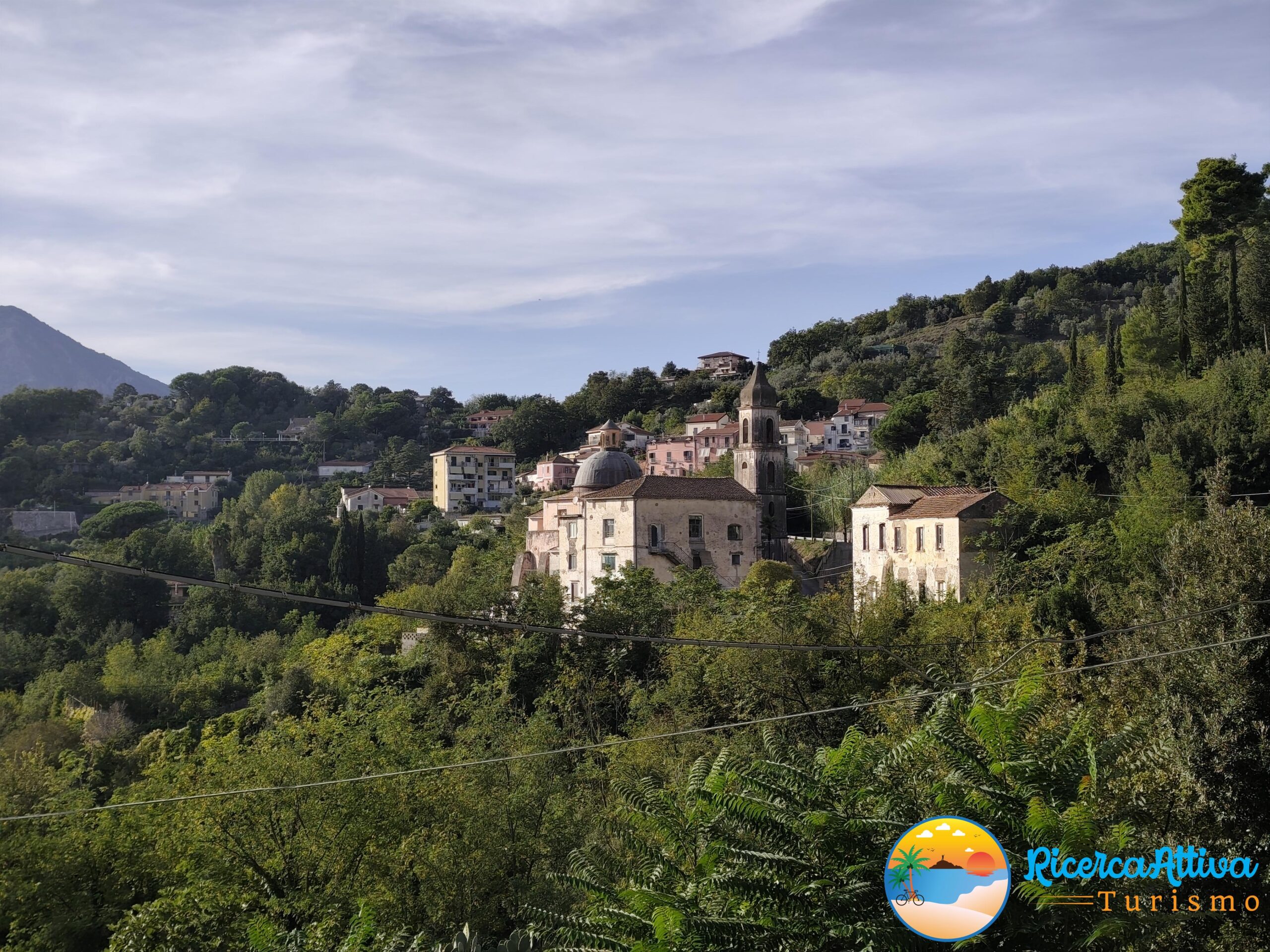
The points of interest that will be observed along the route are: the Soverato seafront, the stele of S. Antonio da Padova located on the belvedere overlooking the Preserre Calabre, the Menzalora which is located in Piazza Regina Elena in Petrizzi and the Porta de Jusu , always in Petrizzi.
You start the Way from the Europa seafront in Soverato and after traveling a couple of kilometers north, you reach the beach which you follow to the Different Beach lido. Then take the SP 124, crossing the bridge over the Beltrame stream, turning into via degli Oleandri and skirting the bed of the Grifo stream and reaching the village of Valaghena . Here begins a challenging climb on a mixed path that leads to an ancient mule track that leads almost to the top of Mount La Rosa, with a panoramic view of the wonderful Gulf of Squillace . A detour to the left will take you to the stele of S.Antonio da Padova, patron of Petrizzi. Take a steep path on the left that leads to the center of the town where, in the central Piazza Regina Elena you will be able to admire the Menzalora which was the unit of measurement of wheat.

Second stage : from Petrizzi to Monterosso Calabro
It takes place over a distance of 23,500 km and is of both medium and difficult difficulty. The fund is 80% unpaved and the rest asphalted.
Along the way you will also cross the village of S. Vito on the Ionian Sea . The points of interest that will be observed are: the spinning mill of S. Vito on the Ionian , the Matrice church of S. Vito Martire, the Acero Lake , the nivere of the ridge of Monte Coppari , the Pietra della Fata , Rocca Capana , the church of the Madonna del Soccorso and the Museum of rural civilization in Monterosso Calabro.
It starts from Piazza Regina Elena in Petrizzi following the signs indicating the Way, along via Dante Alighieri, via Principe di Piemonte up to the church of Santa Maria della Provvidenza. From here you take a small road on the right that climbs slightly up to the course of the Beltrame stream and then, you need to take a country path on the left. You cross a concrete bridge and take a path framed by dry stone walls that leads to the SP 144 which must be taken by turning left and, after about fifty meters, you cross a country road that leads to the now disused track of a littorina. Continue in an environment totally immersed in nature that will lead to the former toll booth of the San Vito sull’Ionio station .
Once in the town, a visit to the Chiesa Matrice and the Filanda is recommended. Leaving the village, you arrive in the well-equipped area of Lake Acero where it is possible to bivouac. The Way continues for a few km on the Sentiero Italia in the direction of the Tyrrhenian Sea and you will meet a significant beech forest that leads to the dorsal side of Monte Coppari: the highest point of the entire route . Here you will have the opportunity to see the numerous niviere and the famous Pietra della Fata from where the descent towards Pozzetti begins and then towards Monterosso Calabro which will offer spectacular and scenic views of Lake Angitola and the Tyrrhenian Sea.
Third stage: from Monterosso Calabro to Pizzo
It winds for 19,100 km and has a medium difficulty. The ground is 60% asphalted and the rest dirt.
The points of interest that can be observed along the last stretch are: the naturalistic oasis of Lake Angitola , the ruins of the Rocca Angitola , the Sanctuary of S. Francesco di Paola di Pizzo , the Cathedral of Paola di Pizzo , the historic center , the Aragonese castle, the church Piedrigrotta , the church of Purgatory , the district Marina di Pizzo .
It starts from the church of Maria del SS. Rescue up to the SP4 which must be traveled for less than a km towards Monterosso Calabro up to the cemetery from where, on the right, you take a country road which is located within an expanse of olive trees and leads near Lake Angitola where it still intersects the SP47 and where, after traveling about 1.3 km, you cross a suitably signposted guardrail to access the naturalistic oasis of Lake Angitola in the Serre Regional Natural Park . From inside the Oasis there is a path that leads back to an uphill road from where you reach the Rocca Angitola and the ruins of the city of Norman origin.
Continue towards Pizzo admiring the Gulf of Sant’Eufemiaand the Pollino National Park . Once in Pizzo, follow the indicated visits and get your Kalabria Coas to Coast passport stamped and receive the end-of-walk testimonial .
Small useful tips
For convenience, we suggest you book accommodation facilities in advance, where you can stay and have meals, and download the GPS map from the official website.
The first and third stages are developed within districts where there are no springs or fountains, so it is imperative to consider providing a sufficient supply of water to cover your needs.
The Way is well organized in terms of signs for which there are wooden signs installed in the main hilly and mountain junctions that indicate Tyrrhenian and Ionian as the direction, as well as there are stickers and conventional signs on the entire route. It must be borne in mind that in the mountain area, the mobile phone signal is not present so it is useful to check-in the Way in the dedicated area in order to be monitored throughout the route until you check-out at the end of the same.
At the points indicated on the official website, you can request the passport that grants discounts and agreements on all the accommodation facilities that are along the route, always indicated on the website.
Turismo.RicercAttiva wishes you “Backpack on your shoulder and a good journey!”


